Thursday, June 26, 2025

The Westrays


Orkney Riddle

The Westrays

 The Knap of Howar


Probably the earliest settlement on the Orkney Archipelago is the Knap of Howar. A Pig bone was found there dated to 3630–3360 (OxA-17778) 

The Knap of Howar sits on a small island called Papa Westray which is one of the northernmost islands of the Orkney group. The island is almost 7 km long and 2 km wide, and the Knap of Howar lies on its west coast. 

Papa Westray is one of a group of islands that are separated from the mainland Orkney group by the Westray and Stronsay Firths. The main islands of this group are Westray, Papa Westray, Sanday, North Ronaldsay, and Stronsay. 

The two oblong buildings of the Knap of Howar, are thought to represent a dwelling-house and a multipurpose workshop-cum-barn, built side by side with an interconnecting passage allowing access from one to the other. 

Excavation revealed traces of a central hearth, footings for wooden benches and post-holes for roof-supports. A stone quern remained in situ, where it may have been used. The adjoining structure is divided into three rooms, the innermost furnished with shelves and cupboards and the middle room acting as the main working area, round a central stone-built hearth.

Many domestic artefacts were recovered, including bone and stone tools, and sherds of round based carinated pottery. (Source RCAHMS) 

The site was excavated by Anna Ritchie and reported in “Excavation of a Neolithic farmstead at Knap of Howar, Papa Westray, Orkney” 

Seren Griffiths’ record of carbon dating for the Knap of Howar in “Beside the Ocean of Time: a chronology of Neolithic burial Monuments and houses in Orkney”  demonstrates that most of the reliable dates from the site more or less pre-date approximately 3000BC. 

Barbara Noddle , in an appendix to Anne Ritchie’s report,  wrote the animal bone report for the Knap of Howar. Her description of the stature of the Knap of Howar pig suggests that it was probably a wild boar, a fearsome creature that was always common in the British Isles, was hunted to extinction in the middle ages, and has been reintroduced in some parts of England. 

The radiocarbon date for the bones of this animal suggest that it must have died at around 3500BC which was some 200 years or so before the earliest sheep bones appear.  It is therefore possible that the first Neolithic visitors to Westray were not accompanied by livestock at all, but that they killed a wild pig that came across their path, and that only later did shepherds bring sheep to Orkney. 

The amount and variety of wildlife remains at the Knap of Howar, the solidity of the structures, and the presence of midden material close to the settlement suggest that these first inhabitants may have attempted to remain on Orkney through winter for several seasons. 

Seren Griffiths’ data suggests that the cattle probably arrived at Orkney, just before 3000BC, but as Barbara Noddle states, they were probably very close to wild aurochs in size and nature. It would probably not be possible to contain these enormous animals simply because they were huge enough that they could walk through any fence, or wall, without even noticing it. 

Barbara Noddle also says that most bones found were juvenile beasts, and I suggest that this may be because young animals would be easier to catch and kill than the adults. (this is not an opinion that is  shared by other authors) 

Very close to Papa Westray is the larger island of Westray, where a large prehistoric settlement remains, called the Links of Noltland. It is understood that in early prehistory Westray and Papa Westray would have been accessible between each other. In this understanding it is reasonable that there will have been some settlement from the same era as the Knap of Howar settlement, at the Links of Noltland.  Some carbon dates quoted in “Links of Noltland, Westray, Orkney. Radiocarbon Dating And chronological Modelling. By Peter Marshall, et al” suggest Neolithic presence there at about 3000BC. 

The pottery from the Knap of Howar is illustrated below:-


Links of Noltland 


The Links of Noltland is located behind Grobust Bay on the North West coast of the island of Westray. It is described in detail in :- “Historic Environment Scotland, Statement of Significance, Links of Noltland” 

The site occupies some 4 hectares of sand dunes and coastal machair.

To date, five settlements comprising of over 35 prehistoric structures have been identified. They are surrounded by contemporary cemeteries, middens and cultivation remains, together with a number of Specialised and ritual buildings. 

Notable discoveries include the ‘Westray Wife’ – a carved stone figurine and The earliest human representation known from Scotland; the Neolithic Cattle Skull house, whose walls contained 28 cattle skulls, some now genetically Identified as auroch and auroch-hybrids; a near-complete subterranean Neolithic house complex containing two further figurines and numerous Carved stones; a Neolithic carved stone ball, found in situ inside a house and; A near-complete subterranean Bronze Age ritual structure, interpreted as a Sauna.


In “Mammals in Late Neolithic Orkney (With reference to mammal bones recovered from Links of Noltland, Westray)”  Sheena Fraser  describes the group of cattle skulls found in a structure known as the Cattle Skull House. 


Cattle skulls in LON Structure 9, with mandibles removed, were carefully placed into midden material lying below the inner and outer foundation course, (between the inner and outer walls of the house) with horn cores orientated downwards into the midden material and skull maxilla and occipital bones upwards.

In addition, in “Links of Noltland, Westray, Orkney Radiocarbon Dating & Chronological Modelling” Peter Marshall et al tabulate the dating of carbon samples from the Links of Noltland “. 

Summarising these sources, in the period before 3000BC, there may have been some occupation close to the Links of Noltland, associated with that at the Knap of Howar. 

However, from around 2800BC to 2300BC the bones found in non-specific locations are either cattle or sheep, and they are largely articulated. The date of death of the skulls in the  cattle skull house fall within the range of this period, but also back to 3000BC. The most recent date for the cattle skulls is 2348BC.

The dating of animal bones recorded reflects the date of death of each animal, but this time of death does not automatically imply the involvement of humans in the process. 

From about 2400BC, areas of animal bones, butchering, and domestic refuse with beaker sherds are present, and at the end of the 3rd millennium BC there are "clear signs of ard cultivation". 

The finding of articulated bones, in comparatively large numbers, is clear evidence that animals were dying here of natural causes, and as there were no scavengers to clear away their carcasses, they rotted where they had fallen. 

A cemetery was also found and excavated at Links of Noltland, and in “Migration and community in Bronze Age Orkney: innovation and continuity at the Links of Noltland,”  Hazel Moore and  Graeme Wilson give the dates of inhumations in the cemetery to be mostly within the 2nd millennium BC. 

This dating strongly suggests that when the Bronze Age “Beaker People“  arrived on the island by boat, they found the remains of the animals that had died in various locations, and perhaps as a way of tidying up their newly colonised territory, incorporated the skulls of the animals into the footings of an early house. 

It may be imagined that to come to an island where the intact skeletons of beasts littered the ground may have been perceived to be a little spooky. 

Referring again to Seren Griffiths, the dates at which the remains of humans, cattle sheep red deer, and grains were present in Orkney are quite revealing. 

60 human bone samples are from cairns, of which 50 date to before 3000BC, and 5 after 2500BC.. 

Sheep are continuously present on Orkney from 3500BC to 2000BC, suggesting that they came with Neolithic shepherds and were left to forage unenclosed. 

With the exception of the one cow sample at the Knap of Howar, the cattle are continuously present in Orkney from 3000BC to 2000BC. This may mean that the cattle were a wild population that inhabited land close to Orkney and that they withdrew to the higher ground that Orkney represented as sea levels rose. 

Red deer are also continuously present from. 3000BC to 2000BC. These animals, with huge mobile territories, may have made landfall in the same way as the cattle did, driven by rising seas onto shrinking islands. 

Grain samples largely precede 3000BC. 

This analysis of Seren Griffiths‘ accumulated data can be used to imply a sequence of events in relation to the occupation of Orkney. 

Sheep were introduced to Orkney by people between 3500BC and 3000BC, and remained as wild population through the 3rd millennium BC. 

Cattle, red deer, Voles, mice, pigs, pine martens, and wolves, were driven from land adjacent to Orkney, as sea levels rose. Animals with otherwise large mobile territories were forced onto islands of smaller and smaller area. 

On the Westrays, Westray and Papa Westray, joined together, and while the Knap of Howar was inhabited there may have been a concurrent settlement at the Links of Noltland. 

When occupation at the Knap of Howar ended, at around 3000BC, cattle and sheep, would still be wandering over the undifferentiated islands of Westray and Papa Westray, looking for the best fodder and shelter, and dying of natural causes. 

Settlement of some sort resumes in the second half of 3rd millennium BC, when boat building technology is likely to have enabled exploration of the archipelago by sea. 

These, the people of the Links of Noltland, would find a wasteland on which the skeletons of Neolithic animals remained littered across the landscape.  They buried the skulls of the animals to hide the parts that made them feel uncomfortable,  and used the rest as a resource for bone tools and fabrications. 

*


All views and opinions expressed are my own, but it remains a work-in-progress for which positive criticism and comment is welcomed.


Jeffery Nicholls 

South Ronaldsay 

Orkney 

The Orkney Riddle (index here) is a series of blogs promoting the notion that Neolithic people walked from Scotland to Orkney to build the Ring of Brodgar. 

#Orkney #archaeology #Neolithic #prehistory #British #SkaraBrae #NessofBrodgar #BIIS ##Britice-Chrono 


Mainland Settlements


 Orkney Riddle

Mainland Settlements 


Sizeable and solid structures in Neolithic Orkney are the cairns, the Knap of Howar, and the complex later structures of Skara Brae and the Ness of Brodgar. In contrast to these are the earlier settlements  which all seem to be shallow and fragile.

The Knowes of Trotty is a settlement on the Bay of Firth, Orkney Mainland. The excavated house is part of a group of eleven mounds, situated at the foot of the steep west slopes of the Ward of Redland. It features a large rectangular hearth, and a small external paved annexe with work areas including an area for pottery manufacture. All 7 carbon samples at this site are likely to pre-date 3000BC  (Nick Card, Jane Downes and Paul Sharman, 2006.) 

Excavation at seven other habitation sites delivered samples that are dated to before 3000BC. They are the Stonehall group, Stonehall Knoll, Stonehall Meadow, and Stonehall Farm, on the Bay of Firth, and not far from them, Wideford Hill and Smerquoy. This group may have been settled in this location because of its position on the lea side of hills around the Bay of Firth. It is relatively sheltered here, and at present trees are more numerous, and growing to greater heights than in other more exposed locations. 

Stonehall Meadow and Wideford Hill are both likely to pre-date 3000BC. Most of the samples from Stonehall farm are likely to pre-date 3000BC, but one is from the 28th century BC settlement

Smerquoy was established and abandoned before 3000BC, but may have been re-occupied at the end of the 3rd millennium BC, a thousand years later. 

The same thing happens at Habreck which is on the island of Wyre, abandonment before 3000BC, and reoccupation a thousand years later. The re-occupation of these sites would not have been as a result of people retuning to structures. It is likely that the abandoned settlements would have developed soils that encouraged the sowing of seeds, and the growth of wild food crops. 

On the island of Eday is Green, which  was occupied and abandoned before 3000BC. 

Stonehall Knoll stands out as an anomaly, as it has three samples from a thin layer of burnt material, with dates from three different centuries : the 32nd, 30th, and 26th. All three of these samples from the one layer may have been redeposited and trampled into the ground at any time after the 26th century BC. 

None of the foregoing habitation sites have any of the structural integrity of buildings that would permit their inhabitants to survive an Orkney winter. (The "Orkney Winter" is like a character in a melodramatic play. It has it's own character, and it's own temperament that overcasts ordinary mortal life on the archipelago. Survival through winter can be uncomfortable now, and must have been challenging 5000 years ago.).


Indigenous American Teepee 


*


All views and opinions expressed are my own, but it remains a work-in-progress for which positive criticism and comment is welcomed.

Jeffery Nicholls 

South Ronaldsay 

Orkney 


The Orkney Riddle (index here) is a series of blogs promoting the notion that Neolithic people walked from Scotland to Orkney to build the Ring of Brodgar. 

#Orkney #archaeology #Neolithic #prehistory #British #SkaraBrae #NessofBrodgar #BIIS ##Britice-Chrono 


Bere Barley, a "Neolithic" Grain


 Orkney Riddle

Bere Barley, a "Neolithic" Grain


Bere, pronounced “bear” is a six-row barley which when milled becomes Bere Meal. It is still grown and used today in Orkney to make a traditional flatbread called a Bannock. It is probably Britain’s oldest cereal in continuous commercial cultivation.

The domestication of the Bere Barley grain is likely to have begun soon after the retreat of the last ice age, when plants, animals, and humans first colonised the vast plains of the North European continental shelf, an area east, west, and north of Orkney.

The grain probably initially adapted itself to the local climatic conditions, and the process of domestication was continued when humans would collect the heads of the primitive wild barley, selecting for size to make the nutritional content of the cereal worth the effort of extracting it from the seed head.

The theory implies that the continued viability of seeds or grains as they were carried into higher latitudes required them to be adapted to environmental conditions starkly different to those under which they were first domesticated.

The plant that is created under these circumstances is known as a “landrace”, which is defined as a domesticated, locally adapted, traditional variety of a species of animal or plant that has developed over time, through adaptation to its environment and isolation from other populations of the species.

Bere Barley, Hordeum Vulgare L. , is the ancient grains that is found on the Outer Hebrides and Orkney.

Barley (Hordeum vulgare ssp. Vulgare) was one of the first and earliest crops domesticated by humans. Currently, archaeological and genetic evidence indicates barley is a mosaic crop, developed from several populations in at least five regions: Mesopotamia, the northern and southern Levant, the Syrian desert and, 900–1,800 miles (1,500–3,000 kilometers) to the east, in the vast Tibetan Plateau.

The wild progenitor of all of the barleys is thought to be Hordeum spontaneum (L.), a winter-germinating species which is native to a very wide region of Eurasia, from the Tigris and Euphrates river system in Iraq to the western reaches of the Yangtze River in China. Based on evidence from Upper Paleolithic sites such as Ohalo II in Israel, wild barley was harvested for at least 10,000 years before it was domesticated.

Barley as a whole is well-adapted to marginal and stress-prone environments, and a more reliable plant than wheat or rice in regions which are colder or higher in altitude.”(Hirst)

Rather than an imported grain, modified by human agency, Bere Barley was probably self-adapted.

Different environmental conditions exist in Orkney, compared to those normally found over much of Eurasia.

I hesitate to call anywhere unique, but there are things that make the northern Isles different, and create a different climate, and radically different weather and seasons.

Chief among the factors that condition the climate here is its location on the planet. The gulf Stream is a constant flow of equatorial water that pushes up the Atlantic ocean towards the Arctic ocean bringing warmth to the British Isles. It also brings violent winds to Orkney.

"Searching for the Origins of Bere Barley: a GeometricMorphometric Approach to Cereal LandraceRecognition in Archaeology" by M. Wallace et al.

"The spread of agriculture beyond the regions of cereal domestication in the FertileCrescent of southwest Asia was a lengthy process crossing biogeographic boundaries.Following initial expansion through Anatolia and to Cyprus, domesticated crops reachedsoutheast Europe c.8500 yrs BP, and from there were dispersed along two main routes: a southern route along the Mediterranean, reaching the Iberian peninsula c.7500 yrs BP, anda northwards route passing through central Europe by c.7500 yrs BP and eventuallyreaching northern Scotland c.6000 yrs BP (Bocquet-Appel et al. 2009; Fort 2015). Thecontinued viability of agriculture as it spread across Europe, especially along the latternorthwards trajectory, required crops to adapt to environmental conditions starkly differentto those under which they were first domesticated (Bogucki 2000; Bonsall et al. 2002;Halstead 1989). This is exemplified by adaptations in responsiveness to daylength with thenorthwards spread of agriculture (Jones et al. 2012) and observed adaptation to specificabiotic stresses (George et al. 2014; Schmidt et al. in prep.). Adaptation in crop specieswould have come about through periods of stable cultivation on the edges of newenvironments, leading to the emergence of new, locally adapted landraces."

*

"Scotland’s first farmers: new insights into early farming practices in North-west Europe"

Rosie R. Bishop, Darren R. Gröcke2 , Ian Ralston , David Clarke Daniel H.J. Lee5 , Alexandra Shepherd6, Antonia S. Thomas ,Peter A. Rowley-Conwy & Mike J. Church

Skara Brae and the Braes of Ha’Breck

The UNESCO World Heritage Site of Skara Brae on Orkney’s west Mainland, a surviving complex of stone-built structures, preserves an outstanding record of Neolithic society and economy (Clarke & Sharples 1990; Shepherd 2016). The two main phases of this settlement (Phase 1: c. 2910–2880 to 2860–2840 cal BC, Phase 2: c. 2800–2700 cal BC to 2550–2420 cal BC; Shepherd 2016) each encompassed six to eight buildings, surrounded by accumulated construction and occupation deposits, including two specific midden agglomerations (Shepherd 2016). In 1972–1973, a small cereal assemblage, predominantly of naked barley, together with some emmer wheat and hulled barley (Hordeum sp. hulled), was recovered from an early phase of occupation (Phase 0, c. 3360–3160 cal BC) underlying this main settlement (Figure 3) (Shepherd 2016; Rowley-Conwy & Bishop 2021). In addition, a large assemblage of wild seeds was recovered from the two main phases of the settlement, which post-date the Phase 0 cereal assemblage (Figures 6 & 7).

The site at the Braes of Ha’Breck is located on Wyre, a small island (approximately 1.5 × 2.5km) north of Mainland, Orkney (Thomas & Lee 2012; Farrell et al. 2014). The settlement comprises two timber-built and three stone-built structures, with evidence for several phases of construction, an external working floor, and occupation deposits, including midden deposits (Thomas & Lee 2012). Bayesian modelling of the radiocarbon dates indicates that occupation began c. 3585–3375 cal BC and ended c. 3270–2980 cal BC (Bayliss et al. 2017). Within one of the stone-built structures was a layer of carbonised grain (dated to 3090–2920 cal BC; Garrow et al. 2017)—perhaps a store accidentally burnt in a house fire (Figure 9) (Thomas & Lee 2012; Bishop 2013). This assemblage, which comprises hundreds of thousands of grains, is one of the largest Neolithic cereal assemblages in North-west Europe (Bishop 2015). Elsewhere on site, charred cereals, almost exclusively of naked barley, together with scarce emmer wheat and hulled barley, were recovered in moderate concentrations from a range of negative features, occupation deposits and hearths (Figure 3) (Bishop 2013). Both sites produced evidence for cattle and sheep/goat husbandry, with pig also recovered in smaller quantities from Skara Brae (Clarke & Sharples 1990: 75; Thomas & Lee unpublished data).

The δ15N isotope values for the crops at Skara Brae range from 0.9 to 5.3‰ (mean: 3.2‰ ±1.1) (Figures 4 & 5) and are consistent with low-to-moderate levels of manuring (cf. Bogaard et al. 2013). At the Braes of Ha’Breck, there is considerable variation in the δ15N isotope values for the crops (mean: 3.9‰±2.3; range: 0.2‰ to 13.7‰)—greater than at any other site considered here—indicating low, moderate and high levels of manuring. The medium and high δ15N isotope values are unlikely to result from waterlogging. Though no wild seeds were recovered in association with the cereals at Skara Brae (Rowley-Conwy & Bishop 2021), the Δ13C isotope values for the crops from the site indicate relatively dry growing conditions (Figure 4), consistent with growth in the sandy soils of the area (see below). Furthermore, at the Braes of Ha’Breck, seed indicators of wet growing conditions are relatively rare (see Figures 6 & 7; Table S1).

Most of the data from both Orcadian sites fall within the ‘moderate manuring’ range (Figure 4), consistent with the dataset for early cereal agriculture across North-west Europe (Figure 8). This suggests that these crops were mainly cultivated in permanently maintained plots fertilised with nitrogen-enhanced organic material. The consumption of grain from these manured crops could partly explain the relatively high δ15N values observed in Neolithic human remains from Orkney (Schulting et al. 2010).

The very high δ15N isotope values from the Braes of Ha’Breck (8.8‰ and 13.7‰; seeTable S5) are most likely explained by the addition of nitrogen-enhanced organic matter to the soils. The alternative of cultivation directly on a midden, as has been suggested for Neolithic Orkney at Tofts Ness (Guttmann et al. 2006), is both logistically impractical due to unstable surfaces on middens and strategically undesirable because of the likely adverse effects of exploiting such high nitrogen conditions, which would have risked lodging and loss of the crop (cf. Briggs 1978: 302–308). The grains were well preserved, and the samples were reanalysed to ensure accuracy, so charring at high temperatures or analytical error is unlikely, although contamination cannot be ruled out (see OSM2). Similarly high δ15N isotope values for Neolithic naked barley were obtained from Frydenlund in Denmark (13.8‰) (Gron et al. 2021) and Oldenburg LA77 in Germany (13.9‰) (Filipovićet al. 2019), which the latter authors suggest might reflect the use of seaweed fertiliser or manure from seaweed-eating herbivores. The impact of fertilising crops with manure from herbivores with marine diets has yet to be assessed, and crop trials of hulled barley in Orkney using seaweed fertiliser have not produced δ15N crop isotope results above 5.6‰ (Blanz et al. 2019).

The latter result, however, might be explained by the seaweed and soil in this study having similar δ15N values, with recent experiments by Gröcke and colleagues (2021) demonstrating a significant increase in δ15N (up to 15‰) for beans grown in soils fertilised with seaweed and marine fish rich in nitrogen.

The Δ13C values at Skara Brae (14.6–17.9‰; mean: 16.2±0.9) are notably lower than at the Braes of Ha’Breck (16.1–19.8‰; mean: 17.8±0.8) and the other sites considered here (Figures 4 & 5). This probably reflects the relatively low water-retention capacity of the calcareous windblown sands at Skara Brae (Simpson et al. 2006; Scotland’s Soils n.d.) and/or the higher soil salinity resulting from salt spray—both factors that lower Δ13C values (see OSM1). In contrast, Wyre lacks the windblown sand deposits of west Mainland, Orkney, and today the Braes of Ha’Breck is located within an area of non-calcareous gleys, which are a less well-drained soil type (Scotland’s Soils n.d.). Other factors, such as increased openness of the landscape (Heaton 1999), are an unlikely cause of the lower Δ13C values at SkaraBrae, since pollen evidence suggests that both sites were located in relatively open conditions (Fyfe et al. 2013). Drier soils, and hence lower Δ13C values, have also been linked to more steeply sloping topography in semi-arid regions, where water-stress was potentially an issue (Bogaard et al. 2016). Here, however, altitude/slope is unlikely to have been a significant factor, given Scotland’s relatively wet climate (see also Gröcke 1998: 3). Nevertheless, lower rainfall at Skara Brae as a result of changing climate remains a possibility, as the date ranges for the two crop assemblages do not quite overlap. The relatively higher Δ13C values for Balbridie and Dubton Farm—both located inland and well away from saline environments— might reflect greater levels of shading by vegetation, since woodland was more extensive on mainland Scotland than Orkney (Fyfe et al. 2013; Farrell et al. 2014).

The grain from the Orkney sites tends to be smaller than that from the mainland sites (Figure 5). Significantly, there is no correlation between grain size and δ15N or Δ13C isotope values (Figure S1), so these size differences do not reflect manuring rates or the availability of water (Figure 5). Recent studies support this, suggesting that barley grain morphology and size are influenced more by landrace type than growing conditions (e.g. Wallace et al. 2019). The size differences could therefore reflect adaptations to the local conditions (e.g. rainfall, exposure, soil type), perhaps representing the development of separate landraces for Orkney and mainland Scotland. As the Orcadian assemblages are several centuries later in date than Balbridie and Dubton Phase 1, it is also possible that there was size reduction over time.

The range in δ15N values for the available data suggests that the Skara Brae cereals were all grown under the same conditions (individual crop ranges all <5‰), whereas the Braes of Ha’Breck crops were not (individual crop ranges >5‰; Table S3). Caution should be exercised here, however, as this apparent difference may be due to the comparatively low number of grains recovered and the relatively low isotope sample size from Skara Brae. Nonetheless, the range in crop δ13C values for both sites is greater than might be expected if all the grain had been grown together (individual crop ranges all >1.5‰; Table S3). The variable carbon stable isotope values from Skara Brae probably reflect the mixing of different harvests within the deposits. It is likely that animal manure was intentionally spread on fields by people rather than directly by animals grazing on fallow cereal plots; Neolithic domestic herbivore δ15N values for Orkney are typically between 6 and 7‰ (and for Skara Brae the mean sheep δ15N value is 6.5‰), which are comparable to those obtained for wild herbivores in the region (δ15N typically approximately 6‰; Jones & Mulville 2016: 672). This suggests that cattle/sheep consumed little cereal chaff from manured crops.

Notably, the nitrogen and carbon stable isotope values for crops from the conflagration deposit at the Braes of Ha’Breck are just as variable as the values from the other contexts (Table S4), suggesting that the deposit contains multiple stored harvests, or grain grown in different microenvironments. The variable manuring of different harvests, however, does not fully account for the variation in δ15N values. Experiments have shown that after manuring ceases, δ15N values for crops grown on previously manured soils can take many decades (approximately 70 years) to return to unmanured levels (Fraser et al. 2011: 2796). The wide range of values recorded here therefore suggests that crops were grown in a range of locations in the surrounding landscape. This fits with the initial analysis of the potential arable weeds, which suggests cultivation on soils with variable levels of fertility (Bishop 2013). It isimportant to consider the small size of the island, which may have provided relatively restricted locations for optimal cultivation and limited options for wild plant collection. It is possible that crops were therefore grown extensively across the island to buffer against crop failure. Similarly, hazelnut shells are exceptionally rare in the assemblage, suggesting that the gathering of wild plants was not integral to the economy of this site (Bishop 2013). Alternatively, the conflagration deposit may represent a communal store for different households, perhaps including communities on neighbouring islands that had access to different amounts of animal manure and/or land with different levels of fertility. Although no other Neolithic settlements have been discovered on Wyre, the neighbouring island of Rousay features the Skara Brae-style settlement of Rinyo, in addition to a dense concentration of Early Neolithic chambered cairns (Davidson & Henshall 1989), suggesting a relatively wellpopulated landscape.


All views and opinions expressed are my own, but it remains a work-in-progress for which positive criticism and comment is welcomed.


Jeffery Nicholls 

South Ronaldsay 

Orkney 


The Orkney Riddle (index here) is a series of blogs promoting the notion that Neolithic people walked from Scotland to Orkney to build the Ring of Brodgar. 

#Orkney #archaeology #Neolithic #prehistory #British #SkaraBrae #NessofBrodgar #BIIS ##Britice-Chrono 


Barnhouse


Orkney Riddle

 Barnhouse


When the honour of the title UNESCO World Heritage Site was bestowed on Orkney, the two stone circles, Stones of Stenness, Ring of Brodgar, and the Maeshowe Chambered Cairn were the only known, or at least best known, Neolithic monuments at the Brodgar peninsula immediate area.

Since then excavation has uncovered two further sites.

These are Barnhouse, a group of small buildings on the shore of Harray Loch, and the Ness of Brodgar, a huge group of Neolithic buildings nearby. Both these sites inspire us to revise our existing view of how Stone Age people lived and thought.

Barnhouse is close to the Stones of Stenness, and the Maeshowe Cairn, and it sits across the causeway between Lochs Harray and Stenness, from the Ness of Brodgar, and the Ring of Brodgar.


 Location plan of Barnhouse, and the Stones of Stenness.

It was discovered and excavated by Colin Richards between 1985 and 1991, and Collin was not aware, at the time that structures he found there would be directly relatable with the huge complex that was to be found at the Ness of Brodgar in 2003.

Initial thoughts and dating were reported in:- Duration and Materiality: Formal Chronological Models for the Development of Barnhouse, a Grooved Ware Settlement in Orkney By Colin Richards et al

Barnhouse lies adjacent to the Loch of Harray, surrounded by other monuments and sites including the Stones of Stenness nearby, Maeshowe to the east, and Ness of Brodgar, the Ring of Brodgar, and Bookan to the north. Excavations in 1985–91 revealed that a large proportion of the settlement remained intact and the shallow stratigraphy allowed a considerable area of Barnhouse to be examined. Thirteen structures, together with their associated deposits of refuse and the areas between the structures, were excavated.

Occupation was thought to have begun with a group of at least nine concentrically organised houses which partly surrounded an open area, which was interpreted as a communal working area. The subsequent, complicated sequence of developments, outlined below, included various acts of refurbishment, abandonment, and rebuilding, with the penultimate phase of activity involving the construction of a large, monumental structure, surrounded by a clay platform (Structure 8). It was suspected that a second large structure with a platform, similar to Structure 8, had existed beyond the excavated area, to the south-east.

Ceramic finds included around 6000 sherds of Grooved Ware pottery and the lithic finds included four maceheads and several pieces of Arran pitchstone.

Twelve radiocarbon measurements were obtained on single fragments of short-lived charred plant material during the original post-excavation programme, placing the use of the site within the period c. 3500–c. 2900 cal BC, and thereby suggesting that Barnhouse stood at, or near, the beginning of the Grooved Ware ceramic tradition.

None of these Barnhouse buildings has the obvious sense of permanence that dwellings at Skara Brae, or the Knap of Howar have. They are short lived structures, often repaired, and rebuilt, and they date from different times throughout the duration of the settlement. 


It seems unlikely that the walls of these structures at Barnhouse were ever much more than a few courses high, and a reasonable possibility is that most of them, with the exception of Structures 2 and 8, may have been Teepee- or dome-like timber-framed structures covered with animal skin, reed/thatch, or turves. 


Recent analogs for this type of dwelling might include the teepee of the Indigenous North American, or the early 20th century Irish turf house.

Anybody who has lived in Orkney through a normal Orkney winter will recognise that such light structures as these clearly represent, would not survive, or enable their inhabitants to survive, in an Orkney winter of lashing rain and ferocious gales. 


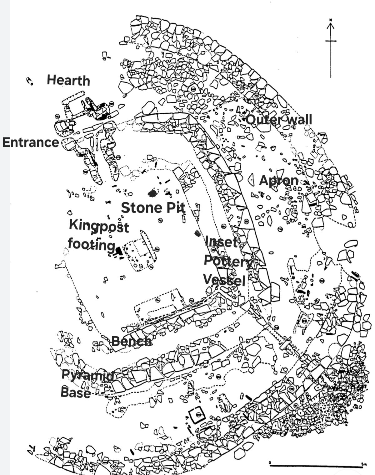
Two structures at Barnhouse, 2 and 8, draw direct parallels with those found later at the Ness of Brodgar. The smaller of the two is Structure 2, a rectangular building, the design of which is known as a “piered building”, as it has stone-built pier-like projections coming out from the mid-points of both of its longer, opposing walls. This design strategy is repeated often, at the Ness of Brodgar. 


The other building that bears comparison between the two sites is Structure 8, a large square building within a circular enclosure. Structure 10 at the Ness of Brodgar is also more or less square, and may have been built using similar techniques to those employed for Structure 8 at Barnhouse. 

Structure 2, the piered structure at Barnhouse was in use for the longest period there, and it was probably built with the intention that it endure for a while, making it clearly an important building. 


The carbon dated samples tested from Barnhouse all essentially pre-date 3000BC, and suggest that the site was only in use for a relatively short period of time. 12 samples, Charred grains and charcoal are broadly dated to between 3650BC and 2870BC. 

Gullies running through the site are cut into the ground surface. These are likely to have been useful for removal of summer rain from the site, but useless in winter. Colin Richards, who excavated the site, says that the numerous circular structures, here, with hearth like features in them were frequently rebuilt, suggesting that they may have may have been abandoned for winter, and refurbished in spring. The presence of upright stone slabs set into the ground in the piered structure, Structure 2, suggests, that this may have been a dormitory. An ephemeral feature outside the entrance to Structure 2 may have been a latrine with a urinal and toilet seat over a simple drainage ditch.


Good evidence in the large feature, Structure 8 suggests that this was a square pyramid shaped building within a sheltering, encircling wall. The wall surround was to protect people on the apron around the building, but more particularly to protect a fire outside the entrance to the structure which served as a sweat Lodge. A light timber framework covered the interior, resting on and attached to a king post in the centre of the building. An inner wall of stone edging served as seating for the participants of the sweat lodge ceremony. A small horde of stones for heating and wetting to create the steam remained, along with a pot set into the ground to store the water and a small pinch pot to carry water from the storage pot to the Stones.

The buildings at Barnhouse are fragile in nature and it is very likely that many more similar structures were once on this shore  of Harray Loch , but have since been destroyed by ancient development, like the Ness of Brodgar,  and by modern agriculture. 


*


All views and opinions expressed are my own, but it remains a work-in-progress for which positive criticism and comment is welcomed.

Jeffery Nicholls 
South Ronaldsay 
Orkney 

The Orkney Riddle (index here) is a series of blogs promoting the notion that Neolithic people walked from Scotland to Orkney to build the Ring of Brodgar. 


#Orkney #archaeology #Neolithic #prehistory #British #SkaraBrae #NessofBrodgar #BIIS ##Britice-Chrono 


Tuesday, June 24, 2025

Cairns of Orkney


 Orkney Riddle


The Cairns of Orkney, (and Britain)


The story of the first migrants to Orkney in the neolithic age is recorded in the archaeological sites and monuments in the archipelago that have survived, and in the scientific research that has allowed an understanding of the dating sequence of their construction and use.

By far the commonest monuments on Orkney are the cairns. There are 60 or so of these, and they were one of the monument types that most attracted curious antiquarian archaeologists.

In pursuance of their interest in finding artefacts, i.e. treasure, these people, perhaps rightly, did not think they would find much by investigating the stone circles of Orkney, but they were very keen to explore the cairns.

The earliest archaeologists in Orkney, had experience and connections with their peers working in England and Scotland, and they as a group, have had a profound influence on our current understanding of “The Stone Age”.

They were almost working in the dark, defining our prehistory, and gradually developing techniques that would inform future generations. They even created the language with which our earliest understanding of prehistory was described.

I have found their descriptions of the excavations they undertook to be highly coloured and detailed. Their reports give a very personal account of their experiences, and a strong sense of being present with them in the darkest recesses of the cairns of Britain.

Those who wrote their views for publication in the annals of the Society of Antiquaries, and other authoritative organisations, drew their inspiration for the findings of the archaeological work that they were undertaking from classical literature and from their knowledge of earlier civilisations elsewhere.

An early investigation of a cairn in England illustrates the attitude in which the purpose of these monuments was viewed at the onset of archaeological investigations in the 19th century. The excavation was carried out by John Thurnam, at the West Kennet Long Barrow in Wiltshire, before 1861, and published in the proceedings of the Society of Antiquaries of London in that year.

Thurnam describes the monument he excavated as one “of those remarkable sepulchral mounds, known as long barrows, which as yet remain the crux and problem of the barrow-digger and archæologist. Many of the long barrows of South Wiltshire were examined at the beginning of this century by Mr. Cunnington and Sir Richard Colt Hoare, but with so little return for the pains bestowed on them, that, though Sir Richard was satisfied of their high antiquity, he was utterly at a loss to determine the purpose for which such immense mounds had been raised.”

In discussing the pottery finds John states that, “The quantity of coarse native pottery was very remarkable. At first it was thought that the heaps in the angles of the chamber would prove to be the fragments of vases, deposited entire when the funeral rites were completed. This, however, was not the case, and whence the fragments came, and why here deposited, must be matter of conjecture. They at least remind us of the “shards, flints, and pebbles,” which our great dramatist connects with the graves of suicides (Hamlet, v. 1), and the use of which in mediæval times may have been a relic of paganism. That the fragments found in the chamber were those of domestic vessels required for the funeral feast, is by no means clear; for in such case, had the mass of fragments been deposited, it would have been possible to have reconstructed at least some of the vessels. As it is, the variety of form and ornament, of colour and texture displayed by them is even more remarkable than their number. In hardly more than three cases were two or more fragments of the same vessel met with. In stating that there were parts of not fewer than fifty different vessels, we shall probably be very much within the truth.”

“It has been already suggested that some of the skeletons in the chamber, on the skulls of which marks of violence are evident, are those of slaves or dependants, immolated on the occasion of the burial of their chief. That this was the custom of the Celtic tribes at one period, cannot be doubted; as Cæsar tells us that, only a little before his time, the Gauls devoted to the funeral pile the favourite slaves and retainers of the dead. Mela even speaks of these immolations as being voluntarily performed, with the hope of joining the dead in a future life. These remarks apply to cremation, the usual though perhaps not universal concomitant of burial among the Gauls in the times of Cæsar and Mela.”

It is clear from John’s account that he had decided that the Long Barrow, and other such structures were burial monuments, and his work was used as a reference by others in the same century who were also enquiring about their purpose.

One of these was Joseph Anderson, Keeper of the National Museum of Antiquities of Scotland, who in 1868 published the result of his research and excavation of a group of horned cairns in Caithness in an article that he entitled the “Horned Cairns of Caithness “. Interestingly he references John Thurnam, and his reporting is more informative for these cairns than for some of his earlier work.

In the process of that work he found a small number of partial skeletons, a lot of fragmentary, both animal and human bones, some flints, stone tools and quantities of pottery from numerous different vessels though none of those were complete.

He writes that “Whether these horned cairns, and, indeed, all the chambered cairns, were originally constructed as sepulchres or as dwellings is another question, on which there may be some difference of opinion. For my own part, I have no hesitation in coming to the conclusion that their original purpose was rather that of honourable mansions for the dead than of serviceable dwellings for the living. I cannot conceive of the expenditure of the enormous amount of labour implied in the construction of a building (as a dwelling) in which the chamber should occupy only about a hundredth part of the capacity of the structure; while, if shelter or defence, or both, had been the object, the chamber (which is the primary object of a building for habitation) could have been made stronger and more serviceable with less than a hundredth part of the toil. If these chambers were ever occupied as habitations, we have found no household implements on their floors, such as are obtained in the brochs—nothing but weapons, ornaments, and pottery, and the common accompaniments of the funereal rites. But, on the other hand, the desire to honour and perpetuate the memory of the mighty dead is motive sufficient to account for the expenditure of any amount of laborious toil, and only those who have seen these enormous cairns and their situations can have any idea of the vast amount of labour expended upon them.”

 And.....“Wherever, among the revolving centuries, the date of these mighty monumental structures may be found, the people that reared them were no despicable barbarians. They are the work of a people possessed of no inconsiderable constructive skill, ingenuity, and resource,—a people numerous, united, and energetic,—and a people, too, of strong reverential feelings and sentiments regarding the sacredness of the remains and memories of those who were dear to them in life, and who may also have been in their day “ the terror of the mighty in the land of the living.””

Perhaps as a result of the isolation of Orkney, many cairns here have remained undisturbed internally, and little trespassed upon since prehistoric times.

One such cairn, that was found to be more or less intact was the Unstan Cairn which is situated on the shore of Stenness Loch.


Unstan Cairn, exterior


Unstan Cairn, interior


Unstan Cairn, plan


It was excavated in 1884 by Robert Stewart Clouston, who declined to comment on the purpose of the structure. He wrote that:-

In the (entrance) passage were found a flint scraper and a barbed arrowhead, also some fragments of pottery. The passage leads, into a large chamber 21 feet long, and averaging about 5(?) feet broad. This is subdivided by large flagstones into five compartments, off the middle one of which is a small side chamber. These compartments of the chamber will be referred to in their numerical order, counting from the southern to the northern end of the chamber, or from left to right in the plan.

In the first compartment were found a considerable quantity of bones, partly human, a curious black substance which appears to me to be a mixture of peat and charcoal, the bottom of a small flat-bottomed urn, and some other fragments of pottery. This compartment was much freer of soil than any of the others, most of it being more easily cleared by the hand than the pick.

At the side of the S.W. flagstone in the second compartment there was a small space, not covered with white clay, and in this we found several fragments of different urns. A more striking instance of how the relics must have been scattered is the fact of a piece of pottery, found in the fourth compartment, fitting into an urn, the rest of which was dug here.. By far the greater portion of the relics found in the chamber were in this compartment. Overlying its clay floor was a stratum of black ashy or earthy matter, largely composed of charcoal, in which great quantities of pottery, and several flint chips and flakes were found.”


“The black stratum which covered the floor of the second compartment extended a couple of feet or so into (the third) compartment, and also into the first compartment and the passage. Upon it were laid several burials in the contracted posture.”

“A large quantity of bones were found in the third compartment, among which, close to the door of the side chamber, opening off it, there were several large vertebrae. A flint implement, 3 inches long, of the class styled by Mr Evans as “fabricators or flaking tools,” was the only relic discovered here, with the exception of a few fragments of pottery.”

“The side chamber opens off the third compartment on its west side.....There were two distinct burials here, in the contracted posture, one of the skulls being the most complete of any of those found, though scarcely half remained. A tooth, which has been pronounced by Dr Garson to be that of a small dog, was found near the door. A stone pounder lay under the bones of one of the skeletons, and this, with two flakes, comprised the whole of the relics found.”

The fourth compartment measures 5 feet 7 inches from east to west and about 4 feet from door to door. Only a few fragments of pottery and a quantity of bones were found here.

The fifth compartment, at the northern extremity of the chamber, is the smallest of the chambers. A small and rudely formed arrow-head was found here. Some burials, and several small fragments of pottery, were also found; also, at a higher level than any other relic, a small piece of ornamented pottery of different pattern from all the others.” (Clouston)

*

The excavation of several cairns in Orkney was carried out in the early 20th century by Charles Calder, and a report on his excavation of a cairn on the Calf of Eday in 1937, observed .....

When Mr Calder made his trial examination of the (Calf of Eday) cairn, in 1935, and discovered the hoard of Neolithic pottery, it was expected that a complete excavation of the monument would be rewarded by the discovery of more vessels and human remains of the period, but this hope was doomed to disappointment, as very little more pottery was recovered and skeletal remains were scanty and in poor condition. However, if the results in the matter of finding such relics were not what was desired, there arises the question why so much broken pottery should be concentrated in one spot.

We know from Mr Walter G. Grant’s excavations of stalled cairns in the island of Rousay that these tombs had been entered after the time of the first burials, possibly when later ones took place. It would appear that pottery previously deposited had received scant attention from newcomers, as not only did vessels get broken but fragments of them were tramped into the floor.

Certainly the pottery found in the cairn must have been heaped together before the roof of the chamber collapsed, and, as the greater part of most of the vessels was wanting, it looks as if most of the pottery had been thrown out of the chamber altogether. It might be suggested that the vessels had been removed from their original positions to make way for the reception of later burials. If this were so, it would seem to indicate a want of reverence, if not for the dead, for the grave furnishings that had been deposited with them. But we have no indication of how many bodies were buried in the cairn, nor of how they were placed, although more than thirty urns were represented by the shards, and so we cannot offer a satisfactory explanation for such treatment of the pottery.

Portions of at least thirty-four vessels of clay have been...... collected..... from...... compartment No. 2, the other compartments, cleared later, were disappointingly barren.


 Calf of Eday, plan and sections

It seems that the whole lot had been gathered together and thrown in a heap, where it was found below the sand amongst black, greasy, peaty humus and peat ash. Along with the pottery were found two leaf-shaped arrow-heads, one broken, and a possible third one damaged, a short knife, two scrapers, and several unworked flakes, all made of flint. The presence of fire in the mixture was attested by the peat ash, carbon, small pieces of calcined bones, and the calcination of all the flints, while soot and ash adhered to the pottery. Two axes of sandstone were found on the shelf above the skeletal remains in compartment No. 4 “

Another pile of broken pottery was found at the Midhowe cairn on Rousay, when it was excavated by Graham Callander, the Director of the National Museum of Scotland, assisted by Walter Grant. They write:-

At the floor-level on the east side of each of the seven cells, Nos. 5 to 11, is a low bench or shelf, from 9 inches to 18 inches high. These shelves had been disturbed and badly broken when the roof fell. On every one of them except that in Cell No. 11 were the remains of from two to four human skeletons. On the west side of the chamber there were no shelves, and only one deposit of human remains was found, this coming from Cell No. 8......


Midhowe, plan and sections.

Most of the pottery was found in the stall on the west side of Cell No. 7,...... It is difficult to understand why the great bulk of the pottery should have been placed in one cell and on the side of it opposite to that on which all the bodies except one were found, and why such small fragments should have survived. It is possible that when later burials were taking place the pottery vessels deposited earlier had been broken, some of the pieces being thrown aside and others trampled underfoot.”

The same team Callander and Grant, excavated the Knowe of Yarso, on Rousay, finding evidence of burning within the chamber:-

All the long bones and many of the human skulls had been smashed and displaced, human and animal bones being mixed up promiscuously. In one place where there were two broken skulls lying near each other, with animal bones between and around them, a deer tooth actually lay within the brain-pan of one. Nowhere was it possible to detect where a single body had been placed, as no limb bones occupied the relative positions of a skeleton either in a crouched or extended position


Knowe of Yarso, plan and sections

......... No less than seventeen adults were represented by skulls usually very much broken, vertebrae, fragments of eight femurs, other leg bones, and two humeri. Nine of the skulls were placed in juxtaposition along the foot of the western wall, six along the opposite side, and two about 15 inches from it. In no case was the lower jaw present. A very fine skull was found in the south-west corner of the cell, touching the divisional slab, which doubtless accounts for its good state of preservation.

Although some of the skulls arranged along the foot of the wall had suffered from disturbance, it seemed that they had been placed cranium upwards facing the centre of the chamber.

The quantity of animal bones found was considerable, and consisted almost entirely of red-deer, many being of the size of the best animals existing in Scotland to-day. Bones from thirty-six of these animals were identified. Ox and sheep were just represented, and there were a few bones of a good-sized dog. The bones were distributed throughout the relic bed of the chamber, but, as already mentioned, were more numerous in the inner half. They were much broken, and included teeth, ribs, and many articular ends and splinters of leg bones. The latter presumably had been deliberately split to get at the marrow. Many of the Yarso animal bones showed distinct marks of scorching and burning......

Pottery was extremely scarce, and what we did find seems to have been deposited at a time later than the original burials.

We have seen that many of the flint implements and some of the animal bones found were calcined. There are also distinct indications of fires burning within all the cells of the chamber, and on both sides.

Many of the stones in the walls are reddened and cracked by fire, and bear traces of soot, from a height of 1 foot 6 inches to 3 feet above the floor. At the same time, quite a lot of pieces of charred wood and ashes were observed in the deposits on the floor. No signs of fires were seen outside the entrance.

One of the skulls........ shows evidence of having been in contact with fire. This would seem to show that the fires had been kindled within the chamber after some of the skulls had been deposited.”

The dating for the bones of the people who died, and we’re laid into cairns in Orkney has been carried out, but the sample is heavily biased, in that it depends on people laying their dead in the structures. In a sense, then, these skeletons are self or kin selected as it is the choice of kin to decide what to do with the body of the deceased.

Of the 70 samples of individuals tested, from 9 Orkney cairn excavations, 56 were found to pre-date 3000BC (80%). A further 9 died between 2995BC and 2800BC (13%).

2 died in the 24th century BC (3%), and 2 in the 15th century BC (3%)

In between the 29th century BC, and the 24th century BC, only one person died, and was laid in a cairn, and that was in 2680BC.


*


Sources :-

(Anderson) On the Horned Cairns of Caithness: their structural arrangement, Contents of chambers l, &c. BY Joseph Anderson , COR. MKM.. S.A. SOOT. (PLATES LX.-LXOrkne

(Calder) , Proceedings of The society of Antiquities Scotland, Neolithic Double-Chambered Cairn Of The Stalled Type And Later Structures On The Calf Of Eday , Orkney . By Charles S. T. Calder.

(Callander) , Proceedings of The society of Antiquities Scotland, A Long Stalled Chambered Cairn Or Mausoleum (Rousay Type ) Near Midhowe , Rousay , Orkney . BY J. Graham Callander, And Walter G. Grant , 1934

(Callander) Proceedings of The society of Antiquities Scotland, A Long , Stalled Cairn , The Knowe Of Yarso , In Rousay , Orkney . By J. Graham Callander, Director Of The National Museum Of Antiquities , And Walter G. Grant , F.S.A.ScoT.

(Clouston) Notice of the Excavation of a Chambered Cairn of The Stone Age , at Unstan , in the Loch of Stennis, Orkney. By Robert Stewart Clouston.

(Lawrence.) Orkneys First Farmers, Reconstructing biographies from osteological analysis to gain insights into life and society in a Neolithic community on the edge of Atlantic Europe. David Michael Lawrence

(Thurnam) , Examination of a chambered long barrow at West Kennet, Wiltshire communicated to the Society of Antiquaries by John Thurnam , ESQ ., M.D. , F.S.A.


*


Index

Next:- "Dem bones, Dem bones"  


All views and opinions expressed are my own, but it remains a work-in-progress for which positive criticism and comment is welcomed.

Jeffery Nicholls 

South Ronaldsay 

Orkney 

The Orkney Riddle (index here) is a series of blogs promoting the notion that Neolithic people walked from Scotland to Orkney to build the Ring of Brodgar. 

#Orkney #archaeology #Neolithic #prehistory #British #SkaraBrae #NessofBrodgar #BIIS ##Britice-Chrono 


Orkney Riddle Index

  Orkney Riddle  Index This is the southern tip of South Ronaldsay,  close to the Tomb of the Eagles.  The island offshore is called the Pen...